Trail On foot Rovigo - Il Cammino di Sant'Antonio: Tappa 4 - Photo

Il Cammino di Sant'Antonio: Tappa 4

Tous les sentiers balisés d’Europe PRO

© OpenStreetMap contributors
Length
Length
20 km
Max alt
Max alt
12 m
Uphill gradient
Uphill gradient
83 m
Km-Effort
Km-Effort  
21 km
Min alt
Min alt
-4 m
Downhill gradient
Downhill gradient
86 m
Boucle
Boucle
No
Signpost
Signpost
Creation date :
2022-02-17 11:11:07.585
Updated on :
2022-03-02 02:54:48.03

(0 Reviews)

On foot
On foot
4h49
Difficulty : Medium

Scan this QR Code to open this trail in the SityTrail application

FREE GPS app for hiking

Logo SityTrail SityTrail

IGN / Geographical institutes

Download SityTrail from the App Store Download SityTrail from Google Play

Logo SityTrail SityTrail World

The world is yours!

Download SityTrail from the App Store Download SityTrail from Google Play Download SityTrail on Huawei AppGallery

About

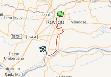
Trail On foot of 20 km to be discovered at Veneto, Rovigo, Rovigo. This trail is proposed by SityTrail - itinéraires balisés pédestres.

Description

Trail created by Frati della Basilica del Santo Padova.


Website: http://www.ilcamminodisantantonio.org

Photos

Positioning

Country:
Italy
Region :
Veneto
Department/Province :
Rovigo
Municipality :
Rovigo
Location:
Unknown
Start:(UTM)
719951 ; 4994795 (32T) N.

Trails nearby

Trail On foot Monselice - Sentiero Monte Ricco e del Monte Castello - Photo
On foot
PRO

On foot

Easy
Monselice, Veneto, Padova, Italy
3.1 km | 5 km-effort
1h 7min
Yes


Close
My subscriptions