


01 Track-13763-F-MNT

noelphil
User
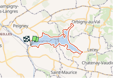

Length
15.1 km

Max alt
364 m

Uphill gradient
141 m
Km-Effort
17 km

Min alt
333 m

Downhill gradient
135 m
Boucle
Yes
Creation date :
2022-02-17 14:32:21.899
Updated on :
2022-02-17 15:02:48.721
3h51
Difficulty : Difficult

FREE GPS app for hiking
 SityTrail
IGN / Geographical institutes
SityTrail Plus
The world is yours!
About
Trail Walking of 15.1 km to be discovered at Grand Est, Haute-Marne, Chatenay-Mâcheron. This trail is proposed by noelphil.
Positioning
Country:
France
Region :
Grand Est
Department/Province :
Haute-Marne
Municipality :
Chatenay-Mâcheron
Location:
Unknown
Start:(Dec)
Start:(UTM)
677514 ; 5304015 (31T) N.
Comments