


tour du col de mandray

jojo02
User
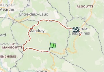

Length
10.9 km

Max alt
737 m

Uphill gradient
390 m
Km-Effort
16.7 km

Min alt
410 m

Downhill gradient
549 m
Boucle
No
Creation date :
2022-02-18 10:23:40.838
Updated on :
2022-02-18 11:58:22.567
1h34
Difficulty : Difficult

FREE GPS app for hiking
 SityTrail
IGN / Geographical institutes
SityTrail Plus
The world is yours!
About
Trail Trail of 10.9 km to be discovered at Grand Est, Vosges, Mandray. This trail is proposed by jojo02.
Positioning
Country:
France
Region :
Grand Est
Department/Province :
Vosges
Municipality :
Mandray
Location:
Unknown
Start:(Dec)
Start:(UTM)
352216 ; 5340644 (32U) N.
Comments