


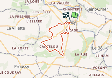
Les Hauts Vents Départd de Clécy

michelberrier
User

Length
10.5 km

Max alt
211 m

Uphill gradient
347 m
Km-Effort
15.1 km

Min alt
47 m

Downhill gradient
349 m
Boucle
Yes
Creation date :
2022-02-18 21:36:07.215
Updated on :
2022-02-18 21:36:58.731
3h26
Difficulty : Easy

FREE GPS app for hiking
 SityTrail
IGN / Geographical institutes
SityTrail Plus
The world is yours!
About
Trail On foot of 10.5 km to be discovered at Normandy, Calvados, Clécy. This trail is proposed by michelberrier.
Positioning
Country:
France
Region :
Normandy
Department/Province :
Calvados
Municipality :
Clécy
Location:
Unknown
Start:(Dec)
Start:(UTM)
684418 ; 5421215 (30U) N.
Comments