


Bellignat Evron retour voie douce

cailloux54
User
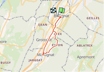

Length
10.1 km

Max alt
596 m

Uphill gradient
123 m
Km-Effort
11.7 km

Min alt
506 m

Downhill gradient
123 m
Boucle
Yes
Creation date :
2022-02-19 13:29:55.593
Updated on :
2022-02-19 15:35:11.959
1h56
Difficulty : Easy

FREE GPS app for hiking
 SityTrail
IGN / Geographical institutes
SityTrail Plus
The world is yours!
About
Trail Walking of 10.1 km to be discovered at Auvergne-Rhône-Alpes, Ain, Bellignat. This trail is proposed by cailloux54.
Positioning
Country:
France
Region :
Auvergne-Rhône-Alpes
Department/Province :
Ain
Municipality :
Bellignat
Location:
Unknown
Start:(Dec)
Start:(UTM)
702381 ; 5124173 (31T) N.
Comments