


Angeville

Alouest31
User
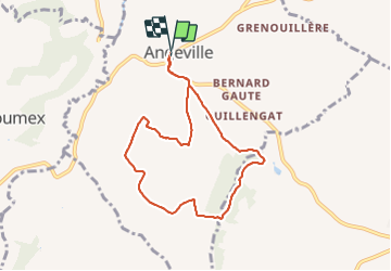

Length
7.8 km

Max alt
162 m

Uphill gradient
119 m
Km-Effort
9.4 km

Min alt
107 m

Downhill gradient
119 m
Boucle
Yes
Creation date :
2022-02-20 13:06:52.609
Updated on :
2022-02-20 15:19:01.77
2h11
Difficulty : Medium

FREE GPS app for hiking
 SityTrail
IGN / Geographical institutes
SityTrail Plus
The world is yours!
About
Trail Walking of 7.8 km to be discovered at Occitania, Tarn-et-Garonne, Angeville. This trail is proposed by Alouest31.
Positioning
Country:
France
Region :
Occitania
Department/Province :
Tarn-et-Garonne
Municipality :
Angeville
Location:
Unknown
Start:(Dec)
Start:(UTM)
341807 ; 4873805 (31T) N.
Comments