


Echaillon

raygautier
User
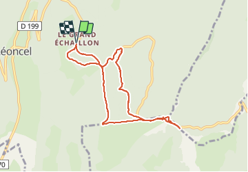

Length
8.4 km

Max alt
1356 m

Uphill gradient
239 m
Km-Effort
11.6 km

Min alt
1178 m

Downhill gradient
240 m
Boucle
Yes
Creation date :
2022-02-20 13:01:22.0
Updated on :
2022-02-21 09:43:02.439
3h09
Difficulty : Unknown

FREE GPS app for hiking
 SityTrail
IGN / Geographical institutes
SityTrail Plus
The world is yours!
About
Trail Walking of 8.4 km to be discovered at Auvergne-Rhône-Alpes, Drôme, Léoncel. This trail is proposed by raygautier.
Positioning
Country:
France
Region :
Auvergne-Rhône-Alpes
Department/Province :
Drôme
Municipality :
Léoncel
Location:
Unknown
Start:(Dec)
Start:(UTM)
674304 ; 4975631 (31T) N.
Comments