


baulneles étangs

SUPERMAMINOU2004
User
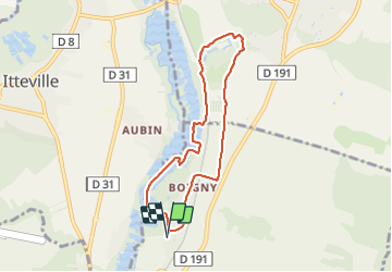

Length
6.7 km

Max alt
74 m

Uphill gradient
47 m
Km-Effort
7.4 km

Min alt
49 m

Downhill gradient
47 m
Boucle
Yes
Creation date :
2022-02-21 08:53:32.654
Updated on :
2022-02-21 10:41:25.277
1h47
Difficulty : Medium

FREE GPS app for hiking
 SityTrail
IGN / Geographical institutes
SityTrail Plus
The world is yours!
About
Trail Walking of 6.7 km to be discovered at Ile-de-France, Essonne, Baulne. This trail is proposed by SUPERMAMINOU2004.
Positioning
Country:
France
Region :
Ile-de-France
Department/Province :
Essonne
Municipality :
Baulne
Location:
Unknown
Start:(Dec)
Start:(UTM)
452977 ; 5371850 (31U) N.
Comments