


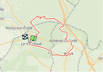
Le vaudoué
© OpenStreetMap contributors


4h55
Difficulty : Medium


Length
16.4 km
Max alt
126 m
Uphill gradient
151 m
Km-Effort
18.4 km
Min alt
70 m
Downhill gradient
151 m
Boucle
Yes
Creation date :
2022-02-22 08:47:23.0
Updated on :
2022-02-22 13:43:50.665
4h55
Difficulty : Medium
FREE GPS app for hiking
 SityTrail
IGN / Geographical institutes
SityTrail Plus
The world is yours!
About
Trail Walking of 16.4 km to be discovered at Ile-de-France, Seine-et-Marne, Le Vaudoué. This trail is proposed by marc.lavot@wanadoo.fr.
Positioning
Country:
France
Region :
Ile-de-France
Department/Province :
Seine-et-Marne
Municipality :
Le Vaudoué
Location:
Unknown
Start:(Dec)
Start:(UTM)
464431 ; 5355780 (31U) N.
Comments