


serre de crema chaudebonne

losjo
User
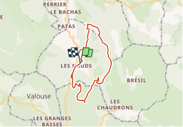

Length
14.1 km

Max alt
1383 m

Uphill gradient
896 m
Km-Effort
26 km

Min alt
648 m

Downhill gradient
896 m
Boucle
Yes
Creation date :
2022-02-22 08:04:47.495
Updated on :
2022-02-22 18:43:03.066
9h03
Difficulty : Very difficult

FREE GPS app for hiking
 SityTrail
IGN / Geographical institutes
SityTrail Plus
The world is yours!
About
Trail Walking of 14.1 km to be discovered at Auvergne-Rhône-Alpes, Drôme, Chaudebonne. This trail is proposed by losjo.
Description
rando technique
Positioning
Country:
France
Region :
Auvergne-Rhône-Alpes
Department/Province :
Drôme
Municipality :
Chaudebonne
Location:
Unknown
Start:(Dec)
Start:(UTM)
676640 ; 4927376 (31T) N.
Comments
belle rando mais très technique surtout en hiver avec le vent et la neige. Il faut être très prudent.