


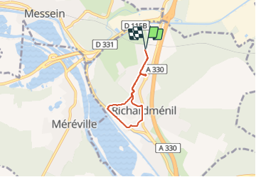
Le village Richardmenil

topnature !
User

Length
4.3 km

Max alt
263 m

Uphill gradient
58 m
Km-Effort
5.1 km

Min alt
224 m

Downhill gradient
57 m
Boucle
Yes
Creation date :
2022-02-23 12:48:24.0
Updated on :
2022-02-23 14:07:13.34
1h17
Difficulty : Easy

FREE GPS app for hiking
 SityTrail
IGN / Geographical institutes
SityTrail Plus
The world is yours!
About
Trail Walking of 4.3 km to be discovered at Grand Est, Meurthe-et-Moselle, Richardménil. This trail is proposed by topnature !.
Description
Depuis la maison
Positioning
Country:
France
Region :
Grand Est
Department/Province :
Meurthe-et-Moselle
Municipality :
Richardménil
Location:
Unknown
Start:(Dec)
Start:(UTM)
291388 ; 5387320 (32U) N.
Comments