


Soleilhas, La Sagne, Chapelle St Pierre, Cascade de Veiraillon 3542 ET

verotrail
User
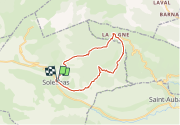

Length
13.1 km

Max alt
1359 m

Uphill gradient
650 m
Km-Effort
22 km

Min alt
1062 m

Downhill gradient
650 m
Boucle
Yes
Creation date :
2022-02-25 16:12:40.95
Updated on :
2022-02-25 16:14:22.88
4h57
Difficulty : Difficult

FREE GPS app for hiking
 SityTrail
IGN / Geographical institutes
SityTrail Plus
The world is yours!
About
Trail On foot of 13.1 km to be discovered at Provence-Alpes-Côte d'Azur, Alpes-de-Haute-Provence, Soleilhas. This trail is proposed by verotrail.
Positioning
Country:
France
Region :
Provence-Alpes-Côte d'Azur
Department/Province :
Alpes-de-Haute-Provence
Municipality :
Soleilhas
Location:
Unknown
Start:(Dec)
Start:(UTM)
311220 ; 4858711 (32T) N.
Comments
Trop bien