


Paysac-Champmajour 15km

thonyc
User GUIDE
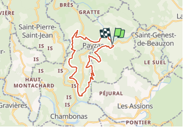

Length
15.2 km

Max alt
411 m

Uphill gradient
449 m
Km-Effort
21 km

Min alt
206 m

Downhill gradient
444 m
Boucle
Yes
Creation date :
2022-02-26 10:29:06.064
Updated on :
2022-02-26 10:40:13.159
4h30
Difficulty : Medium

FREE GPS app for hiking
 SityTrail
IGN / Geographical institutes
SityTrail Plus
The world is yours!
About
Trail Walking of 15.2 km to be discovered at Auvergne-Rhône-Alpes, Ardèche, Payzac. This trail is proposed by thonyc.
Positioning
Country:
France
Region :
Auvergne-Rhône-Alpes
Department/Province :
Ardèche
Municipality :
Payzac
Location:
Unknown
Start:(Dec)
Start:(UTM)
592188 ; 4922667 (31T) N.
Comments