


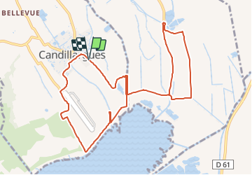
Candillargues - Marais - Cabannes de Forton et le Cayrel

jlbesancon
User


2h42
Difficulty : Medium

FREE GPS app for hiking
 SityTrail
IGN / Geographical institutes
SityTrail Plus
The world is yours!
About
Trail Walking of 12.6 km to be discovered at Occitania, Hérault, Candillargues. This trail is proposed by jlbesancon.
Description
Magnifique balade dans les marais, n'oubliez pas les jumelles, l'avifaune est riche et variée. Les cabanes de Lansargues avec le petit pont sont un lieu très pittoresque. A noter, au retour il existe une variante qui n'est pas praticable en période de hautes eaux, le chemin est très souvent inondé. Après avoir passer le pont au nord du canal de Lansargues prendre à droite le chemin qui passe au nord du pré de Cayrel. Il rejoint le pont sur le Bérange sous réserve de passer le fossé sur une une planche en travers avant d'arriver au pont.
Positioning
Comments