


ROBION FONTAINE DE VAUCLUSE

denel
User
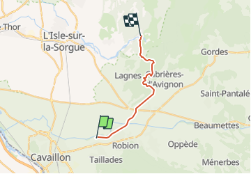

Length
13.1 km

Max alt
319 m

Uphill gradient
283 m
Km-Effort
16.9 km

Min alt
80 m

Downhill gradient
288 m
Boucle
No
Creation date :
2022-02-26 20:39:34.836
Updated on :
2022-03-04 19:19:45.824
3h22
Difficulty : Easy

FREE GPS app for hiking
 SityTrail
IGN / Geographical institutes
SityTrail Plus
The world is yours!
About
Trail Walking of 13.1 km to be discovered at Provence-Alpes-Côte d'Azur, Vaucluse, Cavaillon. This trail is proposed by denel.
Description
Rejoindre Fontaine de Vaucluse à partir du Mas Honorat
Positioning
Country:
France
Region :
Provence-Alpes-Côte d'Azur
Department/Province :
Vaucluse
Municipality :
Cavaillon
Location:
Unknown
Start:(Dec)
Start:(UTM)
667500 ; 4857270 (31T) N.
Comments