


tuc de la tese

petit-pied
User
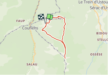

Length
12.3 km

Max alt
2226 m

Uphill gradient
1268 m
Km-Effort
29 km

Min alt
945 m

Downhill gradient
1277 m
Boucle
Yes
Creation date :
2022-02-27 08:32:09.08
Updated on :
2022-02-27 16:27:25.334
6h57
Difficulty : Very difficult

FREE GPS app for hiking
 SityTrail
IGN / Geographical institutes
SityTrail Plus
The world is yours!
About
Trail Walking of 12.3 km to be discovered at Occitania, Ariège, Ustou. This trail is proposed by petit-pied.
Positioning
Country:
France
Region :
Occitania
Department/Province :
Ariège
Municipality :
Ustou
Location:
Unknown
Start:(Dec)
Start:(UTM)
353130 ; 4739156 (31T) N.
Comments