


St Fortunat retour par chemin du Pontay

gdela
User
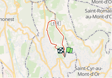

Length
4.2 km

Max alt
511 m

Uphill gradient
142 m
Km-Effort
6.1 km

Min alt
368 m

Downhill gradient
146 m
Boucle
Yes
Creation date :
2022-02-27 15:37:43.429
Updated on :
2022-02-28 15:48:20.08
1h14
Difficulty : Medium

FREE GPS app for hiking
 SityTrail
IGN / Geographical institutes
SityTrail Plus
The world is yours!
About
Trail Walking of 4.2 km to be discovered at Auvergne-Rhône-Alpes, Métropole de Lyon, Saint-Didier-au-Mont-d'Or. This trail is proposed by gdela.
Photos


Positioning
Country:
France
Region :
Auvergne-Rhône-Alpes
Department/Province :
Métropole de Lyon
Municipality :
Saint-Didier-au-Mont-d'Or
Location:
Unknown
Start:(Dec)
Start:(UTM)
640186 ; 5075750 (31T) N.
Comments