


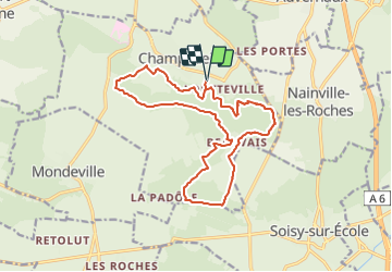
Champcueil Louteville Forêt des Grands Avaux

michelberrier
User

Length
16.5 km

Max alt
152 m

Uphill gradient
284 m
Km-Effort
20 km

Min alt
81 m

Downhill gradient
285 m
Boucle
Yes
Creation date :
2022-02-27 18:26:56.407
Updated on :
2022-02-27 18:28:06.961
4h36
Difficulty : Medium

FREE GPS app for hiking
 SityTrail
IGN / Geographical institutes
SityTrail Plus
The world is yours!
About
Trail On foot of 16.5 km to be discovered at Ile-de-France, Essonne, Champcueil. This trail is proposed by michelberrier.
Positioning
Country:
France
Region :
Ile-de-France
Department/Province :
Essonne
Municipality :
Champcueil
Location:
Unknown
Start:(Dec)
Start:(UTM)
460075 ; 5373126 (31U) N.
Comments