


2022-02-27_22h26m08_1645997102505_SityTrail - 3056792 - mont-saint-martin-mandelieu

verotrail
User
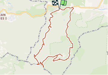

Length
11.2 km

Max alt
371 m

Uphill gradient
389 m
Km-Effort
16.4 km

Min alt
16 m

Downhill gradient
387 m
Boucle
Yes
Creation date :
2022-02-27 21:26:08.242
Updated on :
2022-02-27 21:26:06.01

FREE GPS app for hiking
 SityTrail
IGN / Geographical institutes
SityTrail Plus
The world is yours!
About
Trail of 11.2 km to be discovered at Provence-Alpes-Côte d'Azur, Maritime Alps, Mandelieu-la-Napoule. This trail is proposed by verotrail.
Positioning
Country:
France
Region :
Provence-Alpes-Côte d'Azur
Department/Province :
Maritime Alps
Municipality :
Mandelieu-la-Napoule
Location:
Unknown
Start:(Dec)
Start:(UTM)
330550 ; 4821197 (32T) N.
Comments