


220228 Dinant citadelle réalisé

guy284
User
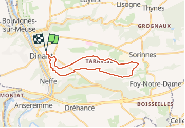

Length
12 km

Max alt
267 m

Uphill gradient
191 m
Km-Effort
14.5 km

Min alt
172 m

Downhill gradient
191 m
Boucle
Yes
Creation date :
2022-02-28 12:59:28.684
Updated on :
2022-02-28 15:58:56.928
2h41
Difficulty : Difficult

FREE GPS app for hiking
 SityTrail
IGN / Geographical institutes
SityTrail Plus
The world is yours!
About
Trail Walking of 12 km to be discovered at Wallonia, Namur, Dinant. This trail is proposed by guy284.
Positioning
Country:
Belgium
Region :
Wallonia
Department/Province :
Namur
Municipality :
Dinant
Location:
Unknown
Start:(Dec)
Start:(UTM)
636610 ; 5569467 (31U) N.
Comments