


Chaligny les hauts de Taye

topnature !
User
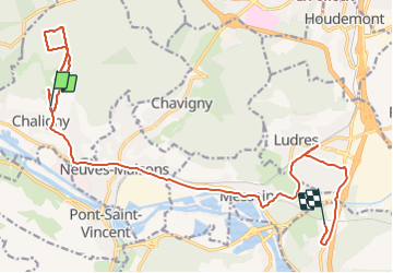

Length
19.3 km

Max alt
417 m

Uphill gradient
267 m
Km-Effort
23 km

Min alt
216 m

Downhill gradient
363 m
Boucle
No
Creation date :
2022-02-28 13:26:09.0
Updated on :
2022-02-28 16:32:15.666
3h04
Difficulty : Easy

FREE GPS app for hiking
 SityTrail
IGN / Geographical institutes
SityTrail Plus
The world is yours!
About
Trail Walking of 19.3 km to be discovered at Grand Est, Meurthe-et-Moselle, Chaligny. This trail is proposed by topnature !.
Description
Le chemin du charbonnier
Positioning
Country:
France
Region :
Grand Est
Department/Province :
Meurthe-et-Moselle
Municipality :
Chaligny
Location:
Unknown
Start:(Dec)
Start:(UTM)
285120 ; 5390268 (32U) N.
Comments