


Chambly

avdem
User
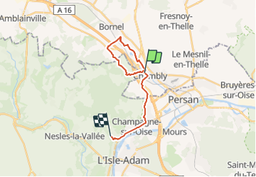

Length
17 km

Max alt
94 m

Uphill gradient
177 m
Km-Effort
19.3 km

Min alt
24 m

Downhill gradient
166 m
Boucle
No
Creation date :
2022-03-01 08:27:07.246
Updated on :
2022-03-01 11:16:56.28
2h29
Difficulty : Easy

FREE GPS app for hiking
 SityTrail
IGN / Geographical institutes
SityTrail Plus
The world is yours!
About
Trail Walking of 17 km to be discovered at Hauts-de-France, Oise, Chambly. This trail is proposed by avdem.
Description
tres bien
Photos


Positioning
Country:
France
Region :
Hauts-de-France
Department/Province :
Oise
Municipality :
Chambly
Location:
Unknown
Start:(Dec)
Start:(UTM)
444523 ; 5446419 (31U) N.
Comments