


La Celle St Cloud

c.chehere
User
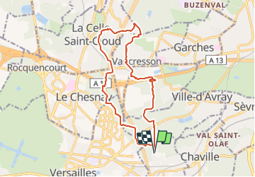

Length
15.4 km

Max alt
184 m

Uphill gradient
255 m
Km-Effort
18.8 km

Min alt
133 m

Downhill gradient
256 m
Boucle
Yes
Creation date :
2022-03-01 08:20:32.016
Updated on :
2022-03-01 17:24:04.904
3h33
Difficulty : Medium

FREE GPS app for hiking
 SityTrail
IGN / Geographical institutes
SityTrail Plus
The world is yours!
About
Trail Walking of 15.4 km to be discovered at Ile-de-France, Yvelines, Viroflay. This trail is proposed by c.chehere.
Description
Randonnée forestière en très grande partie
Positioning
Country:
France
Region :
Ile-de-France
Department/Province :
Yvelines
Municipality :
Viroflay
Location:
Unknown
Start:(Dec)
Start:(UTM)
438787 ; 5406653 (31U) N.
Comments