


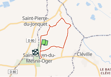
st ouen du mesnil oger

nono1425
User

Length
5.1 km

Max alt
25 m

Uphill gradient
32 m
Km-Effort
5.5 km

Min alt
3 m

Downhill gradient
24 m
Boucle
No
Creation date :
2014-12-10 00:00:00.0
Updated on :
2014-12-10 00:00:00.0
1h20
Difficulty : Unknown

FREE GPS app for hiking
 SityTrail
IGN / Geographical institutes
SityTrail Plus
The world is yours!
About
Trail Walking of 5.1 km to be discovered at Normandy, Calvados, Saint-Ouen-du-Mesnil-Oger. This trail is proposed by nono1425.
Description
facile et sympatique
Photos

Positioning
Country:
France
Region :
Normandy
Department/Province :
Calvados
Municipality :
Saint-Ouen-du-Mesnil-Oger
Location:
Unknown
Start:(Dec)
Start:(UTM)
709822 ; 5449156 (30U) N.
Comments
tres bien pour debut