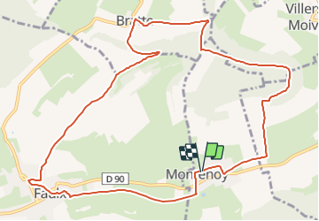
Montenoy_Brattes_Faulx par Vassuchamp_12km

ZAMBAUX
User

Length
12 km

Max alt
419 m

Uphill gradient
301 m
Km-Effort
16.1 km

Min alt
227 m

Downhill gradient
303 m
Boucle
Yes
Creation date :
2022-03-03 18:22:13.046
Updated on :
2022-03-03 18:23:31.043
3h39
Difficulty : Difficult

FREE GPS app for hiking
 SityTrail
IGN / Geographical institutes
SityTrail Plus
The world is yours!
About
Trail Walking of 12 km to be discovered at Grand Est, Meurthe-et-Moselle, Montenoy. This trail is proposed by ZAMBAUX.
Positioning
Country:
France
Region :
Grand Est
Department/Province :
Meurthe-et-Moselle
Municipality :
Montenoy
Location:
Unknown
Start:(Dec)
Start:(UTM)
296549 ; 5408354 (32U) N.
Comments