


Voie Combault

Spinnaker
User
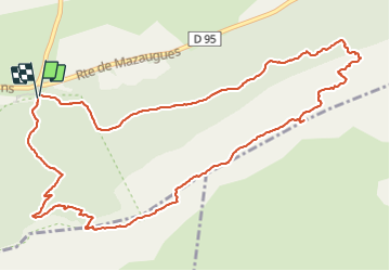

Length
6.9 km

Max alt
1127 m

Uphill gradient
447 m
Km-Effort
12.8 km

Min alt
683 m

Downhill gradient
439 m
Boucle
Yes
Creation date :
2022-03-04 08:23:05.509
Updated on :
2022-03-04 12:48:27.601
4h24
Difficulty : Very difficult

FREE GPS app for hiking
 SityTrail
IGN / Geographical institutes
SityTrail Plus
The world is yours!
About
Trail Walking of 6.9 km to be discovered at Provence-Alpes-Côte d'Azur, Var, Plan-d'Aups-Sainte-Baume. This trail is proposed by Spinnaker.
Positioning
Country:
France
Region :
Provence-Alpes-Côte d'Azur
Department/Province :
Var
Municipality :
Plan-d'Aups-Sainte-Baume
Location:
Unknown
Start:(Dec)
Start:(UTM)
724208 ; 4801754 (31T) N.
Comments