


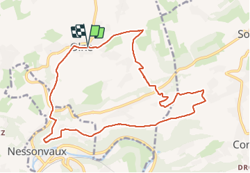
Olne adeps
© OpenStreetMap contributors


2h21
Difficulty : Medium


Length
9.9 km
Max alt
284 m
Uphill gradient
257 m
Km-Effort
13.3 km
Min alt
123 m
Downhill gradient
256 m
Boucle
Yes
Creation date :
2022-03-06 12:07:53.0
Updated on :
2022-03-06 14:56:36.551
2h21
Difficulty : Medium
FREE GPS app for hiking
 SityTrail
IGN / Geographical institutes
SityTrail Plus
The world is yours!
About
Trail Walking of 9.9 km to be discovered at Wallonia, Liège, Olne. This trail is proposed by chantal.dgdl@hotmail.com.
Description
Olne adeps 10 km
Positioning
Country:
Belgium
Region :
Wallonia
Department/Province :
Liège
Municipality :
Olne
Location:
Unknown
Start:(Dec)
Start:(UTM)
694630 ; 5607839 (31U) N.
Comments