


la molignee

le koyote
User
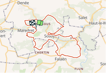

Length
21 km

Max alt
265 m

Uphill gradient
527 m
Km-Effort
28 km

Min alt
128 m

Downhill gradient
524 m
Boucle
Yes
Creation date :
2022-03-06 09:36:53.35
Updated on :
2022-03-06 16:08:51.67
5h56
Difficulty : Difficult

FREE GPS app for hiking
 SityTrail
IGN / Geographical institutes
SityTrail Plus
The world is yours!
About
Trail Walking of 21 km to be discovered at Wallonia, Namur, Anhée. This trail is proposed by le koyote.
Positioning
Country:
Belgium
Region :
Wallonia
Department/Province :
Namur
Municipality :
Anhée
Location:
Unknown
Start:(Dec)
Start:(UTM)
625692 ; 5573528 (31U) N.
Comments