


tour des etangs

kikkko
User
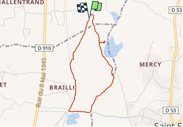

Length
3.6 km

Max alt
372 m

Uphill gradient
24 m
Km-Effort
3.9 km

Min alt
354 m

Downhill gradient
24 m
Boucle
Yes
Creation date :
2022-03-06 14:26:10.386
Updated on :
2022-03-06 16:17:25.294
1h04
Difficulty : Easy

FREE GPS app for hiking
 SityTrail
IGN / Geographical institutes
SityTrail Plus
The world is yours!
About
Trail Walking of 3.6 km to be discovered at Auvergne-Rhône-Alpes, Upper Savoy, Bloye. This trail is proposed by kikkko.
Description
Agréable petite balade familiale
Positioning
Country:
France
Region :
Auvergne-Rhône-Alpes
Department/Province :
Upper Savoy
Municipality :
Bloye
Location:
Unknown
Start:(Dec)
Start:(UTM)
729855 ; 5077614 (31T) N.
Comments