


St Jacques

berger64
User
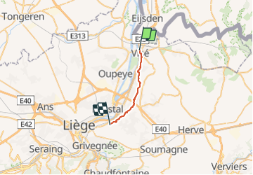

Length
14.7 km

Max alt
186 m

Uphill gradient
282 m
Km-Effort
18.5 km

Min alt
53 m

Downhill gradient
268 m
Boucle
No
Creation date :
2022-03-06 09:05:58.947
Updated on :
2022-03-06 16:39:12.087
5h29
Difficulty : Very easy

FREE GPS app for hiking
 SityTrail
IGN / Geographical institutes
SityTrail Plus
The world is yours!
About
Trail Walking of 14.7 km to be discovered at Wallonia, Liège, Visé. This trail is proposed by berger64.
Description
balisage
Photos


124 photos in total. Please click on a photo to see them all in the gallery.
Positioning
Country:
Belgium
Region :
Wallonia
Department/Province :
Liège
Municipality :
Visé
Location:
Unknown
Start:(Dec)
Start:(UTM)
689971 ; 5624108 (31U) N.
Comments