


rando Paris ponts

GOELERANDO2
User

Length
7.4 km

Max alt
64 m

Uphill gradient
86 m
Km-Effort
8.6 km

Min alt
23 m

Downhill gradient
96 m
Boucle
No
Creation date :
2022-03-07 09:31:33.214
Updated on :
2022-03-07 14:24:53.826
4h51
Difficulty : Medium

FREE GPS app for hiking
 SityTrail
IGN / Geographical institutes
SityTrail Plus
The world is yours!
About
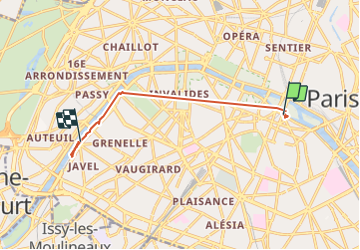
Trail Walking of 7.4 km to be discovered at Ile-de-France, Paris, Paris. This trail is proposed by GOELERANDO2.
Description
quaiq de Paris 03 22
Positioning
Country:
France
Region :
Ile-de-France
Department/Province :
Paris
Municipality :
Paris
Location:
5th Arrondissement
Start:(Dec)
Start:(UTM)
452076 ; 5411305 (31U) N.
Comments