


Chamonix Le Bouchet.Bob G

r.genette
User

Length
8.6 km

Max alt
1110 m

Uphill gradient
105 m
Km-Effort
10 km

Min alt
1035 m

Downhill gradient
105 m
Boucle
Yes
Creation date :
2014-12-10 00:00:00.0
Updated on :
2014-12-10 00:00:00.0
2h30
Difficulty : Unknown

FREE GPS app for hiking
 SityTrail
IGN / Geographical institutes
SityTrail Plus
The world is yours!
About
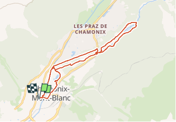
Trail Walking of 8.6 km to be discovered at Auvergne-Rhône-Alpes, Upper Savoy, Chamonix-Mont-Blanc. This trail is proposed by r.genette.
Description
départ Park Hotel vers le Robinson, L'Arveyron, l'héliport secours en montagne, stand de tir du ski de fond, la turbine de la mer des glaces et retour en ville .
Positioning
Country:
France
Region :
Auvergne-Rhône-Alpes
Department/Province :
Upper Savoy
Municipality :
Chamonix-Mont-Blanc
Location:
Unknown
Start:(Dec)
Start:(UTM)
334735 ; 5087713 (32T) N.
Comments