


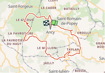
ANCY

JacouBrijou
User

Length
22 km

Max alt
723 m

Uphill gradient
916 m
Km-Effort
34 km

Min alt
383 m

Downhill gradient
923 m
Boucle
Yes
Creation date :
2022-03-08 07:35:03.055
Updated on :
2022-03-08 14:45:33.823
6h24
Difficulty : Difficult

FREE GPS app for hiking
 SityTrail
IGN / Geographical institutes
SityTrail Plus
The world is yours!
About
Trail Walking of 22 km to be discovered at Auvergne-Rhône-Alpes, Rhône, Ancy. This trail is proposed by JacouBrijou.
Description
22 km
Positioning
Country:
France
Region :
Auvergne-Rhône-Alpes
Department/Province :
Rhône
Municipality :
Ancy
Location:
Unknown
Start:(Dec)
Start:(UTM)
617187 ; 5077394 (31T) N.
Comments