


Marignac en diois

alinetpierre
User
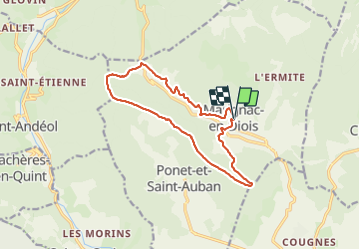

Length
13.8 km

Max alt
1013 m

Uphill gradient
582 m
Km-Effort
22 km

Min alt
574 m

Downhill gradient
579 m
Boucle
Yes
Creation date :
2022-03-09 08:24:17.224
Updated on :
2022-03-09 15:00:39.336
4h16
Difficulty : Medium

FREE GPS app for hiking
 SityTrail
IGN / Geographical institutes
SityTrail Plus
The world is yours!
About
Trail Walking of 13.8 km to be discovered at Auvergne-Rhône-Alpes, Drôme, Marignac-en-Diois. This trail is proposed by alinetpierre.
Description
jolie balade en crêtes
Positioning
Country:
France
Region :
Auvergne-Rhône-Alpes
Department/Province :
Drôme
Municipality :
Marignac-en-Diois
Location:
Unknown
Start:(Dec)
Start:(UTM)
684558 ; 4963547 (31T) N.
Comments