


Entrainement Oxfam 24/06

gue
User
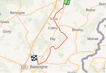

Length
14.8 km

Max alt
557 m

Uphill gradient
286 m
Km-Effort
18.4 km

Min alt
417 m

Downhill gradient
221 m
Boucle
No
Creation date :
2014-12-10 00:00:00.0
Updated on :
2014-12-10 00:00:00.0
2h40
Difficulty : Unknown

FREE GPS app for hiking
 SityTrail
IGN / Geographical institutes
SityTrail Plus
The world is yours!
About
Trail Walking of 14.8 km to be discovered at Wallonia, Luxembourg, Bastogne. This trail is proposed by gue.
Description
pas génial
Positioning
Country:
Belgium
Region :
Wallonia
Department/Province :
Luxembourg
Municipality :
Bastogne
Location:
Noville
Start:(Dec)
Start:(UTM)
698411 ; 5552395 (31U) N.
Comments
bof