


Cruas

raygautier
User
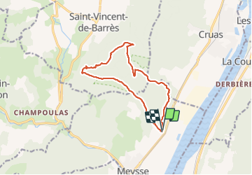

Length
12.9 km

Max alt
505 m

Uphill gradient
522 m
Km-Effort
19.8 km

Min alt
89 m

Downhill gradient
526 m
Boucle
Yes
Creation date :
2022-03-09 08:57:57.0
Updated on :
2022-03-09 18:43:44.515
5h35
Difficulty : Very difficult

FREE GPS app for hiking
 SityTrail
IGN / Geographical institutes
SityTrail Plus
The world is yours!
About
Trail Walking of 12.9 km to be discovered at Auvergne-Rhône-Alpes, Ardèche, Meysse. This trail is proposed by raygautier.
Positioning
Country:
France
Region :
Auvergne-Rhône-Alpes
Department/Province :
Ardèche
Municipality :
Meysse
Location:
Unknown
Start:(Dec)
Start:(UTM)
637947 ; 4942576 (31T) N.
Comments