


2022-03-09_19h48m14_F780

any1950
User

Length
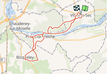
17.6 km

Max alt
329 m

Uphill gradient
317 m
Km-Effort
22 km

Min alt
206 m

Downhill gradient
318 m
Boucle
Yes
Creation date :
2022-03-09 18:48:17.966
Updated on :
2022-03-09 18:48:20.703

FREE GPS app for hiking
 SityTrail
IGN / Geographical institutes
SityTrail Plus
The world is yours!
About
Trail of 17.6 km to be discovered at Grand Est, Meurthe-et-Moselle, Villey-le-Sec. This trail is proposed by any1950.
Positioning
Country:
France
Region :
Grand Est
Department/Province :
Meurthe-et-Moselle
Municipality :
Villey-le-Sec
Location:
Unknown
Start:(Dec)
Start:(UTM)
719271 ; 5393920 (31U) N.
Comments