


chaumont sur Tharonne_Nord-Est

lemuid
User
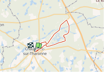

Length
10.6 km

Max alt
148 m

Uphill gradient
96 m
Km-Effort
11.9 km

Min alt
125 m

Downhill gradient
96 m
Boucle
Yes
Creation date :
2022-03-11 08:14:02.436
Updated on :
2022-03-11 12:21:07.652
1h58
Difficulty : Very easy

FREE GPS app for hiking
 SityTrail
IGN / Geographical institutes
SityTrail Plus
The world is yours!
About
Trail Walking of 10.6 km to be discovered at Centre-Loire Valley, Loir-et-Cher, Chaumont-sur-Tharonne. This trail is proposed by lemuid.
Positioning
Country:
France
Region :
Centre-Loire Valley
Department/Province :
Loir-et-Cher
Municipality :
Chaumont-sur-Tharonne
Location:
Unknown
Start:(Dec)
Start:(UTM)
417681 ; 5273584 (31T) N.
Comments