


fretin et ses marais

dehemjacques
User
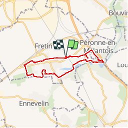

Length
12 km

Max alt
37 m

Uphill gradient
51 m
Km-Effort
12.7 km

Min alt
24 m

Downhill gradient
52 m
Boucle
Yes
Creation date :
2014-12-10 00:00:00.0
Updated on :
2014-12-10 00:00:00.0
2h31
Difficulty : Easy

FREE GPS app for hiking
 SityTrail
IGN / Geographical institutes
SityTrail Plus
The world is yours!
About
Trail Walking of 12 km to be discovered at Hauts-de-France, Nord, Fretin. This trail is proposed by dehemjacques.
Description
marais et voyettes
Positioning
Country:
France
Region :
Hauts-de-France
Department/Province :
Nord
Municipality :
Fretin
Location:
Unknown
Start:(Dec)
Start:(UTM)
510513 ; 5600979 (31U) N.
Comments
très belle randonnée dans les marais et sur les voyettes de fretin