


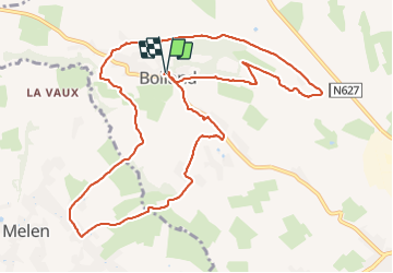
Bolland adeps
© OpenStreetMap contributors


2h35
Difficulty : Medium


Length
11.6 km
Max alt
295 m
Uphill gradient
264 m
Km-Effort
15.1 km
Min alt
193 m
Downhill gradient
267 m
Boucle
Yes
Creation date :
2022-03-13 13:19:19.0
Updated on :
2022-03-13 16:45:22.169
2h35
Difficulty : Medium
FREE GPS app for hiking
 SityTrail
IGN / Geographical institutes
SityTrail Plus
The world is yours!
About
Trail Walking of 11.6 km to be discovered at Wallonia, Liège, Herve. This trail is proposed by chantal.dgdl@hotmail.com.
Description
Bolland
Positioning
Country:
Belgium
Region :
Wallonia
Department/Province :
Liège
Municipality :
Herve
Location:
Unknown
Start:(Dec)
Start:(UTM)
695013 ; 5615843 (31U) N.
Comments
Très beau parcours majoritairement dans les prairies avec de superbes vues sur le paysage bocager du Pays de Herve. ❗ Le 1er sentier à gauche est privé et bien clôturé, donc continuer par la route pour retomber plus haut sur le parcours.