![](/images/other/stat-length.png)
![Trail Walking Saint-Omer - Les rochers de Clécy - Clécy - Photo](https://media.geolcdn.com/t/1900/400/ext.pjpeg?maxdim=2&url=https%3A%2F%2Fservices.sitytrail.com%2FGeolivesWS%2FDownloadMedia.ashx%3FTrailID%3D316659%26Media%3D3517_2.jpg)
Les rochers de Clécy - Clécy
tracegps
User
![Length](/images/other/stat-length.png)
Length
11.6 km
![Max alt](https://static1.geolcdn.com/siteimages/upload/files/1508320355ic_sort_altitude_max_24dp.png)
Max alt
262 m
![Uphill gradient](https://static1.geolcdn.com/siteimages/upload/files/1508320355ic_sort_den_pos_24dp.png)
Uphill gradient
334 m
![Km-Effort](/images/other/stat-length.png)
Km-Effort
16 km
![Min alt](https://static1.geolcdn.com/siteimages/upload/files/1508320355ic_sort_altitude_min_24dp.png)
Min alt
38 m
![Downhill gradient](https://static1.geolcdn.com/siteimages/upload/files/1508320355ic_sort_den_neg_24dp.png)
Downhill gradient
337 m
![Boucle](https://static1.geolcdn.com/siteimages/upload/files/16400158638029165_repeat_loop_refresh_sync_direction_icon.png)
Boucle
Yes
Creation date :
2014-12-10 00:00:00.0
Updated on :
2014-12-10 00:00:00.0
![Walking](https://static1.geolcdn.com/sitytour/trail-icons/101.png)
3h30
Difficulty : Difficult
![Scan this QR Code to open this trail in the SityTrail application](https://capi.geolives.com/qq0zvz2zws4bq2lad0pu/sitytour/trails/316659/qr.png?size=200)
FREE GPS app for hiking
About
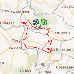
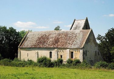
Trail Walking of 11.6 km to be discovered at Normandy, Calvados, Saint-Omer. This trail is proposed by tracegps.
Description
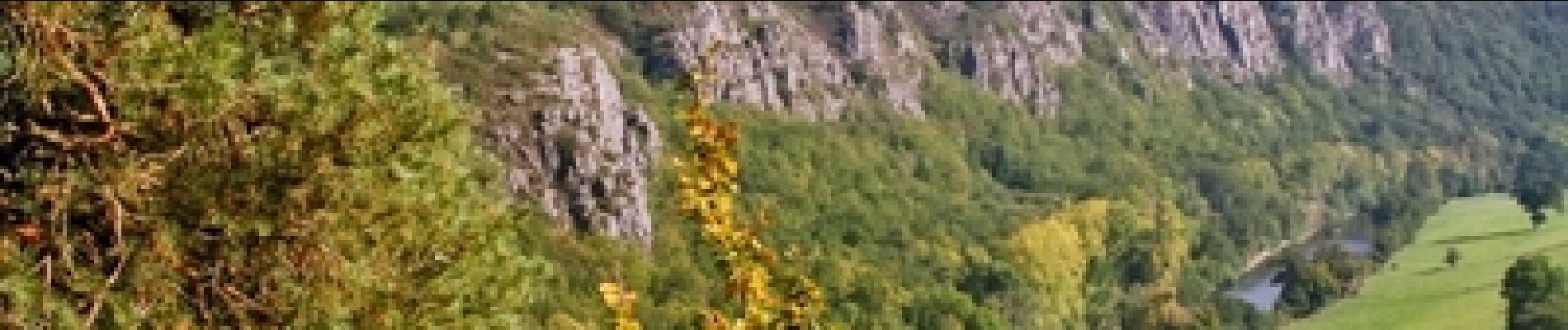
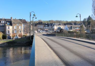
Clécy est un lieu très fréquenté par les randonneurs et vous pourrez constater là que l’appellation «Suisse Normande» se justifie pleinement.
Positioning
Country:
France
Region :
Normandy
Department/Province :
Calvados
Municipality :
Saint-Omer
Location:
Unknown
Start:(Dec)
Start:(UTM)
686512 ; 5422294 (30U) N.
Comments
Trails nearby
![Trail Mountain bike Saint-Omer - Espace VTT FFC de Suisse Normande - Circuit 11 - Saint Omer - Photo](https://media.geolcdn.com/t/375/260/ext.jpg?maxdim=2&url=https%3A%2F%2Fservices.sitytrail.com%2FGeolivesWS%2FDownloadMedia.ashx%3FTrailID%3D106820%26Media%3D11522_1.jpg)
![Mountain bike Mountain bike](https://static1.geolcdn.com/sitytour/trail-icons/202.png)
Espace VTT FFC de Suisse Normande - Circuit 11 - Saint Omer
Mountain bike
Very difficult
(1)
Saint-Omer,
Normandy,
Calvados,
France
![](/images/other/stat-length.png)
25 km | 34 km-effort
3h 0min
![](https://static1.geolcdn.com/siteimages/upload/files/16400158638029165_repeat_loop_refresh_sync_direction_icon.png)
Yes
![Trail Walking Le Vey - Clécy - Photo](https://media.geolcdn.com/t/375/260/ext.jpg?maxdim=2&url=https%3A%2F%2Fmedia.geolcdn.com%2Ff%2F128372da-8bde-41a3-bf52-ea6a6766f39f.jpg)
![Walking Walking](https://static1.geolcdn.com/sitytour/trail-icons/101.png)
![Trail On foot Le Bô - Des Montagnes de Normandie? - Photo](https://media.geolcdn.com/t/375/260/ext.jpg?maxdim=2&url=https%3A%2F%2Fmedia.geolcdn.com%2Ff%2F99446ac7-841c-43b2-a8d0-7ad8496245d0.jpeg)
![On foot On foot](https://static1.geolcdn.com/sitytour/trail-icons/100.png)
Des Montagnes de Normandie?
On foot
Medium
Le Bô,
Normandy,
Calvados,
France
![](/images/other/stat-length.png)
15.4 km | 20 km-effort
4h 38min
![](https://static1.geolcdn.com/siteimages/upload/files/16400158638029165_repeat_loop_refresh_sync_direction_icon.png)
No
![Trail On foot Esson - La Chapelle Bonne Nouvelle - Photo](https://media.geolcdn.com/t/375/260/ext.jpg?maxdim=2&url=https%3A%2F%2Fmedia.geolcdn.com%2Ff%2F82717480-a9c2-41c9-93af-e42d631dbd18.jpeg)
![On foot On foot](https://static1.geolcdn.com/sitytour/trail-icons/100.png)
La Chapelle Bonne Nouvelle
On foot
Easy
Esson,
Normandy,
Calvados,
France
![](/images/other/stat-length.png)
9.5 km | 13.3 km-effort
3h 1min
![](https://static1.geolcdn.com/siteimages/upload/files/16400158638029165_repeat_loop_refresh_sync_direction_icon.png)
Yes
![Trail On foot La Pommeraye - Les Rochers de Briesvieille - Photo](https://media.geolcdn.com/t/375/260/ext.jpg?maxdim=2&url=https%3A%2F%2Fmedia.geolcdn.com%2Ff%2F99446ac7-841c-43b2-a8d0-7ad8496245d0.jpeg)
![On foot On foot](https://static1.geolcdn.com/sitytour/trail-icons/100.png)
Les Rochers de Briesvieille
On foot
Easy
La Pommeraye,
Normandy,
Calvados,
France
![](/images/other/stat-length.png)
9.1 km | 12.9 km-effort
2h 55min
![](https://static1.geolcdn.com/siteimages/upload/files/16400158638029165_repeat_loop_refresh_sync_direction_icon.png)
No
![Trail On foot Le Bô - Le Moulin à Papier - Photo](https://media.geolcdn.com/t/375/260/ext.jpg?maxdim=2&url=https%3A%2F%2Fmedia.geolcdn.com%2Ff%2F3ac248d0-9006-472c-b1a7-3308f2fe9984.jpeg)
![On foot On foot](https://static1.geolcdn.com/sitytour/trail-icons/100.png)
Le Moulin à Papier
On foot
Easy
Le Bô,
Normandy,
Calvados,
France
![](/images/other/stat-length.png)
7.1 km | 9.6 km-effort
2h 11min
![](https://static1.geolcdn.com/siteimages/upload/files/16400158638029165_repeat_loop_refresh_sync_direction_icon.png)
Yes
![Trail On foot Meslay - L'Etang - Photo](https://media.geolcdn.com/t/375/260/ext.jpg?maxdim=2&url=https%3A%2F%2Fmedia.geolcdn.com%2Ff%2Fd974e4f1-b2dd-416a-8ede-5a74b4124efc.jpeg)
![On foot On foot](https://static1.geolcdn.com/sitytour/trail-icons/100.png)
![Trail On foot Esson - GRP Tour de la Suisse Normande - Photo](https://media.geolcdn.com/t/375/260/ext.jpg?maxdim=2&url=https%3A%2F%2Fmedia.geolcdn.com%2Ff%2F96471841-70b2-445a-bcf9-e6471b393594.jpeg)
![On foot On foot](https://static1.geolcdn.com/sitytour/trail-icons/100.png)
GRP Tour de la Suisse Normande
On foot
Difficult
Esson,
Normandy,
Calvados,
France
![](/images/other/stat-length.png)
25 km | 35 km-effort
7h 58min
![](https://static1.geolcdn.com/siteimages/upload/files/16400158638029165_repeat_loop_refresh_sync_direction_icon.png)
No
![Trail Mountain bike Saint-Rémy - VTT Suisse Normande N°10 - St Rémy sur Orne - Photo](https://media.geolcdn.com/t/375/260/ext.jpg?maxdim=2&url=https%3A%2F%2Fservices.sitytrail.com%2FGeolivesWS%2FDownloadMedia.ashx%3FTrailID%3D173106%26Media%3D14655_3.jpg)
![Mountain bike Mountain bike](https://static1.geolcdn.com/sitytour/trail-icons/202.png)
VTT Suisse Normande N°10 - St Rémy sur Orne
Mountain bike
Easy
Saint-Rémy,
Normandy,
Calvados,
France
![](/images/other/stat-length.png)
15.8 km | 20 km-effort
1h 30min
![](https://static1.geolcdn.com/siteimages/upload/files/16400158638029165_repeat_loop_refresh_sync_direction_icon.png)
Yes