


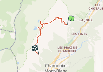
La Flégère - Col du fouet - Lac noir - Lac cornu - Planpraz - 10 km deniv 840 m

jeanmarcMasson
User GUIDE

Length
9.5 km

Max alt
2555 m

Uphill gradient
842 m
Km-Effort
20 km

Min alt
1895 m

Downhill gradient
723 m
Boucle
No
Creation date :
2022-03-15 09:34:54.372
Updated on :
2022-03-15 09:36:43.605
4h37
Difficulty : Very difficult

FREE GPS app for hiking
 SityTrail
IGN / Geographical institutes
SityTrail Plus
The world is yours!
About
Trail Walking of 9.5 km to be discovered at Auvergne-Rhône-Alpes, Upper Savoy, Chamonix-Mont-Blanc. This trail is proposed by jeanmarcMasson.
Positioning
Country:
France
Region :
Auvergne-Rhône-Alpes
Department/Province :
Upper Savoy
Municipality :
Chamonix-Mont-Blanc
Location:
Unknown
Start:(Dec)
Start:(UTM)
336248 ; 5091848 (32T) N.
Comments