


scia par la combe de l'ours

CABERMAT
User
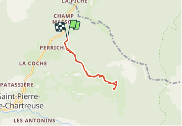

Length
5.5 km

Max alt
1696 m

Uphill gradient
557 m
Km-Effort
12.9 km

Min alt
1131 m

Downhill gradient
543 m
Boucle
Yes
Creation date :
2022-03-15 08:04:59.739
Updated on :
2022-03-15 10:44:52.642
2h39
Difficulty : Very easy

FREE GPS app for hiking
 SityTrail
IGN / Geographical institutes
SityTrail Plus
The world is yours!
About
Trail Touring skiing of 5.5 km to be discovered at Auvergne-Rhône-Alpes, Isère, Saint-Pierre-de-Chartreuse. This trail is proposed by CABERMAT.
Positioning
Country:
France
Region :
Auvergne-Rhône-Alpes
Department/Province :
Isère
Municipality :
Saint-Pierre-de-Chartreuse
Location:
Unknown
Start:(Dec)
Start:(UTM)
721780 ; 5026599 (31T) N.
Comments