


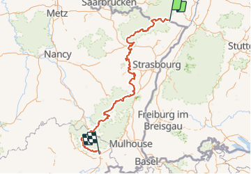
exp_TMV entière ADT.gpx

nicolas54230
User

Length
439 km

Max alt
1254 m

Uphill gradient
11466 m
Km-Effort
592 km

Min alt
158 m

Downhill gradient
11267 m
Boucle
No
Creation date :
2022-03-15 11:11:06.953
Updated on :
2022-03-15 11:12:56.551
41h01
Difficulty : Very difficult

FREE GPS app for hiking
 SityTrail
IGN / Geographical institutes
SityTrail Plus
The world is yours!
About
Trail Mountain bike of 439 km to be discovered at Grand Est, Bas-Rhin, Wissembourg. This trail is proposed by nicolas54230.
Positioning
Country:
France
Region :
Grand Est
Department/Province :
Bas-Rhin
Municipality :
Wissembourg
Location:
Unknown
Start:(Dec)
Start:(UTM)
422857 ; 5432075 (32U) N.
Comments