


Authevernes le petit Rhin du champs pourri

serge.guerroult
User

Length
12.1 km

Max alt
147 m

Uphill gradient
157 m
Km-Effort
14.2 km

Min alt
98 m

Downhill gradient
157 m
Boucle
Yes
Creation date :
2022-03-17 08:19:14.561
Updated on :
2022-03-20 18:27:21.834
3h14
Difficulty : Difficult

FREE GPS app for hiking
 SityTrail
IGN / Geographical institutes
SityTrail Plus
The world is yours!
About
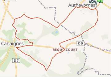
Trail Walking of 12.1 km to be discovered at Normandy, Eure, Authevernes. This trail is proposed by serge.guerroult.
Description
départ de la salle des fêtes en direction du bois du Prussien
Positioning
Country:
France
Region :
Normandy
Department/Province :
Eure
Municipality :
Authevernes
Location:
Unknown
Start:(Dec)
Start:(UTM)
401293 ; 5452584 (31U) N.
Comments