


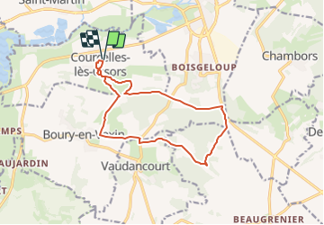
Courcelles vers Hérouval

serge.guerroult
User

Length
12.9 km

Max alt
149 m

Uphill gradient
195 m
Km-Effort
15.5 km

Min alt
59 m

Downhill gradient
195 m
Boucle
Yes
Creation date :
2022-03-17 10:02:59.48
Updated on :
2023-12-27 17:08:00.284
3h30
Difficulty : Difficult

FREE GPS app for hiking
 SityTrail
IGN / Geographical institutes
SityTrail Plus
The world is yours!
About
Trail Walking of 12.9 km to be discovered at Hauts-de-France, Oise, Courcelles-lès-Gisors. This trail is proposed by serge.guerroult.
Description
départ Courcelles la salle des fêtes rejoindre le chemin du Baron via la plaine de vaux, puis hérouval , Boury et retour par le chemin dit la route de Gisors
Positioning
Country:
France
Region :
Hauts-de-France
Department/Province :
Oise
Municipality :
Courcelles-lès-Gisors
Location:
Unknown
Start:(Dec)
Start:(UTM)
408604 ; 5457218 (31U) N.
Comments