


2022-03-17 16:30:14

Blourouce
User
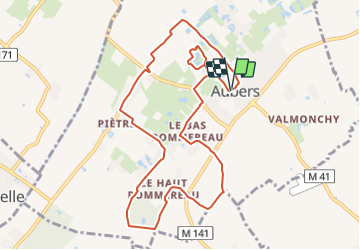

Length
9.7 km

Max alt
41 m

Uphill gradient
58 m
Km-Effort
10.5 km

Min alt
16 m

Downhill gradient
57 m
Boucle
Yes
Creation date :
2022-03-17 17:12:57.175
Updated on :
2022-03-17 17:22:32.068
2h23
Difficulty : Medium

FREE GPS app for hiking
 SityTrail
IGN / Geographical institutes
SityTrail Plus
The world is yours!
About
Trail Walking of 9.7 km to be discovered at Hauts-de-France, Nord, Aubers. This trail is proposed by Blourouce.
Positioning
Country:
France
Region :
Hauts-de-France
Department/Province :
Nord
Municipality :
Aubers
Location:
Unknown
Start:(Dec)
Start:(UTM)
487613 ; 5604858 (31U) N.
Comments