


Le beau soleil N° 2 - Aumale

tracegps
User


2h40
Difficulty : Medium

FREE GPS app for hiking
 SityTrail
IGN / Geographical institutes
SityTrail Plus
The world is yours!
About
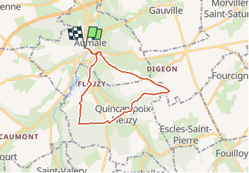
Trail Walking of 10.8 km to be discovered at Normandy, Seine-Maritime, Aumale. This trail is proposed by tracegps.
Description
Circuit proposé par l'Office de Tourisme d'Aumale. Départ de l'Office de Tourisme d'Aumale. Prendre la direction du cimetière, continuer vers Digeon, puis prendre la vallée de Gournay à travers bois pour atteindre Quincampoix-Fleuzy. Traverser la D68, puis la D316 pour traverser le Bois du Varambeaumont. A la maison du garde, prendre à droite pour rejoindre Fleuzy. Après un crochet gauche droite, prendre le chemin de la Verrerie qui devient la rue de la Verrerie jusqu'au cimetière. Prendre la passerelle au dessus de la vois SNCF pour reprendre le parcours pris au départ.
Photos


Positioning
Comments