![](/images/other/stat-length.png)
![Trail Walking Saint-Martin-en-Haut - St Martin En Haut 2013 - Photo](https://media.geolcdn.com/t/1900/400/ext.pjpeg?maxdim=2&url=https%3A%2F%2Fservices.sitytrail.com%2FGeolivesWS%2FDownloadMedia.ashx%3FTrailID%3D317158%26Media%3D16309_4.jpg)
St Martin En Haut 2013
tracegps
User
![Length](/images/other/stat-length.png)
Length
22 km
![Max alt](https://static1.geolcdn.com/siteimages/upload/files/1508320355ic_sort_altitude_max_24dp.png)
Max alt
769 m
![Uphill gradient](https://static1.geolcdn.com/siteimages/upload/files/1508320355ic_sort_den_pos_24dp.png)
Uphill gradient
596 m
![Km-Effort](/images/other/stat-length.png)
Km-Effort
29 km
![Min alt](https://static1.geolcdn.com/siteimages/upload/files/1508320355ic_sort_altitude_min_24dp.png)
Min alt
556 m
![Downhill gradient](https://static1.geolcdn.com/siteimages/upload/files/1508320355ic_sort_den_neg_24dp.png)
Downhill gradient
596 m
![Boucle](https://static1.geolcdn.com/siteimages/upload/files/16400158638029165_repeat_loop_refresh_sync_direction_icon.png)
Boucle
Yes
Creation date :
2014-12-10 00:00:00.0
Updated on :
2014-12-10 00:00:00.0
![Walking](https://static1.geolcdn.com/sitytour/trail-icons/101.png)
5h00
Difficulty : Medium
![Scan this QR Code to open this trail in the SityTrail application](https://capi.geolives.com/qq0zvz2zws4bq2lad0pu/sitytour/trails/317158/qr.png?size=200)
FREE GPS app for hiking
About
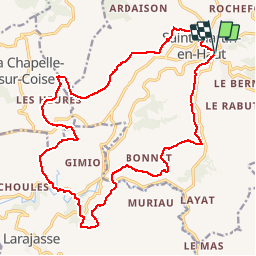
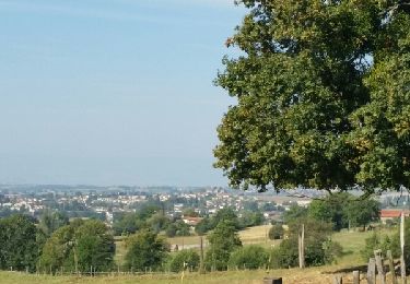
Trail Walking of 22 km to be discovered at Auvergne-Rhône-Alpes, Rhône, Saint-Martin-en-Haut. This trail is proposed by tracegps.
Description
Randonnée organisée par le club de cyclo St Martinois. Circuit aux alentours de St Martin le Haut dans les Monts du Lyonnais.
Positioning
Country:
France
Region :
Auvergne-Rhône-Alpes
Department/Province :
Rhône
Municipality :
Saint-Martin-en-Haut
Location:
Unknown
Start:(Dec)
Start:(UTM)
621866 ; 5057267 (31T) N.
Comments
Trails nearby
![Trail Mountain bike Saint-Martin-en-Haut - 19ème Croisée des Monts du Lyonnais (2012-VTT-25km) / Saint-Martin-en-Haut - Photo](https://media.geolcdn.com/t/375/260/ext.jpg?maxdim=2&url=https%3A%2F%2Fservices.sitytrail.com%2FGeolivesWS%2FDownloadMedia.ashx%3FTrailID%3D129837%26Media%3D13390_6.jpg)
![Mountain bike Mountain bike](https://static1.geolcdn.com/sitytour/trail-icons/202.png)
19ème Croisée des Monts du Lyonnais (2012-VTT-25km) / Saint-Martin-en-Haut
Mountain bike
Medium
(1)
Saint-Martin-en-Haut,
Auvergne-Rhône-Alpes,
Rhône,
France
![](/images/other/stat-length.png)
25 km | 35 km-effort
2h 45min
![](https://static1.geolcdn.com/siteimages/upload/files/16400158638029165_repeat_loop_refresh_sync_direction_icon.png)
Yes
![Trail Walking Thurins - tour du bois du baron - Photo](https://media.geolcdn.com/t/375/260/ext.jpg?maxdim=2&url=https%3A%2F%2Fservices.sitytrail.com%2FGeolivesWS%2FDownloadMedia.ashx%3FTrailID%3D548394%26Media%3Dfix__20160403153341.jpg)
![Walking Walking](https://static1.geolcdn.com/sitytour/trail-icons/101.png)
tour du bois du baron
Walking
Easy
(3)
Thurins,
Auvergne-Rhône-Alpes,
Rhône,
France
![](/images/other/stat-length.png)
7.4 km | 11.5 km-effort
1h 40min
![](https://static1.geolcdn.com/siteimages/upload/files/16400158638029165_repeat_loop_refresh_sync_direction_icon.png)
Yes
![Trail Walking Duerne - Randonnée des collines autour de Duerne - Photo](https://media.geolcdn.com/t/375/260/ext.jpg?maxdim=2&url=https%3A%2F%2Fmedia.geolcdn.com%2Ff%2F56b3b5ff-8854-42cb-926b-a132b104089d.jpg)
![Walking Walking](https://static1.geolcdn.com/sitytour/trail-icons/101.png)
Randonnée des collines autour de Duerne
Walking
Medium
Duerne,
Auvergne-Rhône-Alpes,
Rhône,
France
![](/images/other/stat-length.png)
15.5 km | 22 km-effort
4h 2min
![](https://static1.geolcdn.com/siteimages/upload/files/16400158638029165_repeat_loop_refresh_sync_direction_icon.png)
Yes
![Trail Walking Saint-André-la-Côte - 69-st-andre-la cote-mattiole-20km-640m-mai22 - Photo](https://media.geolcdn.com/t/375/260/ext.jpg?maxdim=2&url=https%3A%2F%2Fmedia.geolcdn.com%2Ff%2F7a464e9e-07ad-49d2-9fc0-eab7bce1d3e5.jpg)
![Walking Walking](https://static1.geolcdn.com/sitytour/trail-icons/101.png)
69-st-andre-la cote-mattiole-20km-640m-mai22
Walking
Medium
Saint-André-la-Côte,
Auvergne-Rhône-Alpes,
Rhône,
France
![](/images/other/stat-length.png)
20 km | 29 km-effort
5h 56min
![](https://static1.geolcdn.com/siteimages/upload/files/16400158638029165_repeat_loop_refresh_sync_direction_icon.png)
Yes
![Trail Walking Saint-André-la-Côte - 69-St-andre-la-cote-Ste-catherine-14km-453m - Photo](https://media.geolcdn.com/t/375/260/ext.jpg?maxdim=2&url=https%3A%2F%2Fmedia.geolcdn.com%2Ff%2F06cb0992-8e16-4e77-b851-837722622855.jpg)
![Walking Walking](https://static1.geolcdn.com/sitytour/trail-icons/101.png)
69-St-andre-la-cote-Ste-catherine-14km-453m
Walking
Medium
Saint-André-la-Côte,
Auvergne-Rhône-Alpes,
Rhône,
France
![](/images/other/stat-length.png)
14.2 km | 20 km-effort
3h 48min
![](https://static1.geolcdn.com/siteimages/upload/files/16400158638029165_repeat_loop_refresh_sync_direction_icon.png)
Yes
![Trail On foot Saint-Martin-en-Haut - Circuit des Sources du Garon - Photo](https://media.geolcdn.com/t/375/260/ext.jpg?maxdim=2&url=https%3A%2F%2Fmedia.geolcdn.com%2Ff%2Ffe014065-bc06-4e54-b660-6900e183f331.jpeg)
![On foot On foot](https://static1.geolcdn.com/sitytour/trail-icons/100.png)
Circuit des Sources du Garon
On foot
Medium
Saint-Martin-en-Haut,
Auvergne-Rhône-Alpes,
Rhône,
France
![](/images/other/stat-length.png)
15.7 km | 22 km-effort
5h 3min
![](https://static1.geolcdn.com/siteimages/upload/files/16400158638029165_repeat_loop_refresh_sync_direction_icon.png)
Yes
![Trail Nordic walking Saint-Martin-en-Haut - Quéser à St Symphonie sur Croise - Photo](https://media.geolcdn.com/t/375/260/ext.jpg?maxdim=2&url=https%3A%2F%2Fservices.sitytrail.com%2FGeolivesWS%2FDownloadMedia.ashx%3FTrailID%3D631037%26Media%3Dfix__20160913104438.jpg)
![Nordic walking Nordic walking](https://static1.geolcdn.com/sitytour/trail-icons/102.png)
Quéser à St Symphonie sur Croise
Nordic walking
Easy
Saint-Martin-en-Haut,
Auvergne-Rhône-Alpes,
Rhône,
France
![](/images/other/stat-length.png)
8.7 km | 11.3 km-effort
2h 38min
![](https://static1.geolcdn.com/siteimages/upload/files/16400158638029165_repeat_loop_refresh_sync_direction_icon.png)
No
![Trail Nordic walking Saint-Martin-en-Haut - St Martin en Haut à Duerne - Photo](https://media.geolcdn.com/t/375/260/ext.jpg?maxdim=2&url=https%3A%2F%2Fservices.sitytrail.com%2FGeolivesWS%2FDownloadMedia.ashx%3FTrailID%3D631033%26Media%3Dfix__20160914102310.jpg)
![Nordic walking Nordic walking](https://static1.geolcdn.com/sitytour/trail-icons/102.png)
St Martin en Haut à Duerne
Nordic walking
Easy
Saint-Martin-en-Haut,
Auvergne-Rhône-Alpes,
Rhône,
France
![](/images/other/stat-length.png)
14.8 km | 19.8 km-effort
5h 33min
![](https://static1.geolcdn.com/siteimages/upload/files/16400158638029165_repeat_loop_refresh_sync_direction_icon.png)
Yes
![Trail Mountain bike Saint-Martin-en-Haut - Balade VTT à St Martin En Haut - Photo](https://media.geolcdn.com/t/375/260/ext.jpg?maxdim=2&url=https%3A%2F%2Fservices.sitytrail.com%2FGeolivesWS%2FDownloadMedia.ashx%3FTrailID%3D317424%26Media%3D16653_3.jpg)
![Mountain bike Mountain bike](https://static1.geolcdn.com/sitytour/trail-icons/202.png)
Balade VTT à St Martin En Haut
Mountain bike
Difficult
Saint-Martin-en-Haut,
Auvergne-Rhône-Alpes,
Rhône,
France
![](/images/other/stat-length.png)
25 km | 35 km-effort
2h 30min
![](https://static1.geolcdn.com/siteimages/upload/files/16400158638029165_repeat_loop_refresh_sync_direction_icon.png)
Yes