


balisage marche 24 km

bena42
User
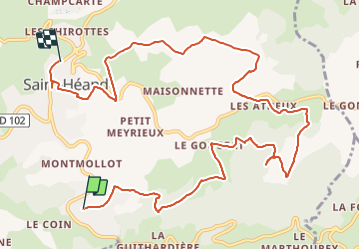

Length
12.5 km

Max alt
873 m

Uphill gradient
384 m
Km-Effort
17.7 km

Min alt
662 m

Downhill gradient
391 m
Boucle
No
Creation date :
2022-03-19 07:29:27.849
Updated on :
2022-03-19 10:08:21.526
2h38
Difficulty : Medium

FREE GPS app for hiking
 SityTrail
IGN / Geographical institutes
SityTrail Plus
The world is yours!
About
Trail Mountain bike of 12.5 km to be discovered at Auvergne-Rhône-Alpes, Loire, Saint-Héand. This trail is proposed by bena42.
Positioning
Country:
France
Region :
Auvergne-Rhône-Alpes
Department/Province :
Loire
Municipality :
Saint-Héand
Location:
Unknown
Start:(Dec)
Start:(UTM)
607668 ; 5041043 (31T) N.
Comments